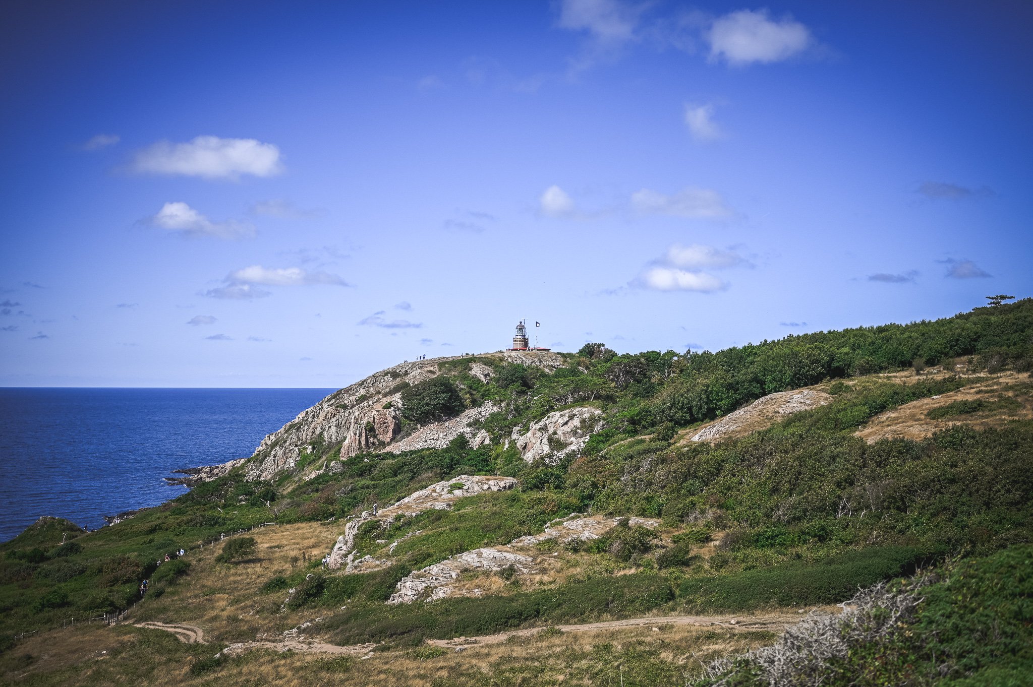
Kullaberg was no stranger to me (I had the opportunity to go to Kullens Fyr once). However, only this year we went exploring the surrounding trails on foot. I invite you to a post in which I will present the most important information about Kullabergs Naturreservat.
Description of the Kullabergs Naturreservat
Kullaberg is a peninsula crossing the Kattegat strait, which is famous for its high cliffs, reaching up to 100 meters into the sea. The landscape is diverse – in addition to vast forests and glades, you can admire the jagged, rocky coastline and numerous caves. Everybody will find something for themselves.

How to get there?
Kullaberg is located in the Skåne region, in the municipality of Höganäs. You can start hiking in several places, because there are many parking lots in the reserve. The authorities of the reserve warn, however, that on weekends, holidays and in the high season it is very difficult to find parking spaces. On the pages there is an appeal to get to the place by other methods. Why not try a bike tour or public transport?
By bus
From Höganäs to Mölle you can take bus number 222, from where you will have to walk about 5 km to Naturum located by the Kullens Fyr lighthouse. During the summer season, you can take bus 202 between Mölle and Kullens Fyr.
By car
If you are coming from the south, take route 111 from Helsingborg via Höganäs to Mölle. From the north, take road 112 from Ängelholm towards Höganäs. You will find the most popular car parks in Mölle by the church or at Kullens Fyr. There is a large car park with over 300 spaces. Unfortunately, car parks in this area are often crowded (especially in summer and on weekends). Mölle streets, on the other hand, are very narrow and winding, which makes it difficult to find parking spaces.
Flora and Fauna at Kullabergs Naturreservat
There is a great diversity of landscape in the reserve. In the deciduous forests you will encounter many blooming flowers. In poorer, rocky areas, you will come across bear’s garlic and yellow anemones, among others. Around the highest point (Håkull, 187 m above sea level), where the ground is more rocky, there are areas covered with grasses and low shrubs. The official website of the reserve states that almost 2/3 of the species found in all of Sweden can be found here.
Among the species typical for this reserve, we distinguish mainly birds. The king of the area is the peregrine falcon, but you can also meet gannets and seagulls here.
Life also thrives in the surrounding waters – they are home to many species of shellfish, sea urchins, brittle stars and mussels. Staring at the surface of the sea, you have a chance to see the fins of porpoises that live in this area emerging above the surface.
Trails in the reserve
Four hiking trails run through the reserve – red, blue, yellow and orange SL5 (Skåneleden 5). We haven’t gone through any of them in their entirety so far because they’re quite long. Our route covered a part of the SL5 route between Mölle and Kullens Fyr.

In Kullabergs Naturreservat you will also find two bicycle trails (including one for a mountain bike), as well as horse trails (as horse tourism is very popular and practiced here).
Thematic educational routes have also been prepared – geological (including local caves and swamps), cultural and sightseeing.
Relax and rest
In the reserve, on the available routes, there are two restaurants and one bar/buffet. where you can sit down, relax, eat and drink something. At one of the restaurants (in Ransvik) there is a rocky beach with a descent into the water, where you can take a bath on warm days. There are many places on the trails where it is nice to stop and rest, have a picnic or sunbathe in the glades.

For lovers of camping there will also be something nice. Since there are 8 camping places near the main car park in front of Kullens Fyr, you can successfully pitch a tent and spend the night.
Highlights of Kullabergs Naturreservat
Kullens Fyr
The most popular point, which is also the final stage of most visitors to the Kullaberg reserve. It is a lighthouse located at an altitude of 78.5 meters above sea level. The current structure was designed by Magnus Dahlander in 1898. It is known, however, that this is not the first lighthouse in this place. The lens design was delivered in 1900, consists of three lenses that rotate four times per minute, with three flashes per rotation. Kullens Fyr is considered the brightest lighthouse in Scandinavia – currently it belongs to the Swedish Maritime Administration (Sjöfartsverket).
Ransvik
Ransvik is a charming place within the Kullabergs Naturreservat. One of the trails leading to Kullens Fyr (SL5) leads through it – leaving it, you can hit a small, rocky beach with a descent into the water. There you can take a bath in the Öresund strait or sunbathe. Hungry and thirsty will also find something for themselves. Noteworthy is a small eatery opened nearby, serving classic Swedish dishes with an Italian twist, as well as coffee and desserts. The entire menu is based on seasonal products and is regularly changed depending on the season.

Caves
Sources say that there are nearly 100 different caves with varying degrees of accessibility in the reserve. You can reach some of them easily, because they will lie on the trail and have prepared descents. Others will be more difficult to explore and will be suitable for really experienced people.
The following three caves are marked as easy, while our experience at Lahibiagrottan is rather difficult, so for each of these places I recommend getting good clothes and planning a trip in good weather conditions.
Lahibiagrottan
It is located along the SL5 trail, just before the last ascent to Kullens Fyr. You will certainly notice the descent to it without any problems, because it is indicated by a decorative wooden plaque. After getting to the other side of the forest, you will see a rope and a steep descent down. When I say steep, I mean really steep. Due to this, without good shoes, do not try to go down there, and without experience, rather go there in the summer, dry season.

The view is definitely worth the effort – the cave overlooks the Öresund strait. The water is clear and it is worth trying to swim in this place. An unforgettable experience. The cave is 9 meters long and 6 meters wide.
Silvergrottan
The name comes from the historical purpose of this grotto, which was originally a mine. Skåne was a Danish province at the time, so it was the Danish King Fredrik II who wanted to start mining here. What appeared to be silver ore was found there, but it was eventually proven to be a mistake. After digging 15 meters, further attempts were stopped.
The cave is 15 meters long and 1 meter wide. It is especially spectacular in winter, when the flowing water creates ice cascades on the walls. The descent to it is just before Lahibiagrottan, going from the lighthouse.
Visitgrottan
The name is relatively new, it comes from the “business cards” of tourists visiting this place carved in the rock. Previously, it had several names, among others it was called the Viking cave. It is 11 meters long and 9 meters wide. Access in winter can be difficult. This is due to the icing on the stairs leading to the cave. Specialists advise using spikes.
You can reach it by leaving the SL5 and walking towards Kullens Fyr (from Ransvik) – along the way you will come across wooden signposts that will show you the direction. The second option is to go down from the Kullaberg main car park. In the north-western part of the parking lot you will find a path – follow it towards the town of Mölle until you see a fork leading towards the sea (there should also be signposts there).
Useful information
Address (to Naturum): Italienska vägen 323, 263 77 Mölle
Website: Kullabergs Natur
Google Maps coordinates (to Naturum): 56.30128454182433, 12.45188959789538
Other entries about Kullabergs Naturreservat
- Trail SL5 from Mölle to Kullens Fyr through Ransvik (coming soon)


